.svg "Anguilla 3")

Anguilla
Full adult suffrage was introduced to Anguilla in 1952. After a brief period as part of the West Indies Federation (1958–62), the island of Anguilla became part of the associated state of Saint Kitts-Nevis-Anguilla with full internal autonomy in 1967. However many Anguillans had no wish to be a part of this union, and resented the dominance of St Kitts within it. On 30 May 1967 Anguillans forcibly ejected the St Kitts police force from the island and declared their separation from St Kitts following a referendum. The events, led by Atlin Harrigan and Ronald Webster amongst others, became known as the Anguillan Revolution; its goal was not independence per se, but rather independence from Saint Kitts and Nevis and a return to being a British colony.
With negotiations failing to break the deadlock, a second referendum confirming Anguillans’ desire for separation from St Kitts was held and the Republic of Anguilla was declared unilaterally, with Ronald Webster as president. Efforts by British envoy William Whitlock failed to break the impasse and 300 British troops were subsequently sent in March 1969. British authority was restored, and confirmed by the Anguilla Act of July 1971. In 1980, Anguilla was finally allowed to formally secede from Saint Kitts and Nevis and become a separate British Crown colony (now a British overseas territory). Since then, Anguilla has been politically stable, and has seen a large growth in its tourism and offshore financing sectors.
Geography:
Anguilla is a flat, low-lying island of coral and limestone in the Caribbean Sea, measuring some 16 miles (26 km) long and 3.5 miles (6 km) in width. It lies to the east of Puerto Rico and the Virgin Islands and directly north of Saint Martin, separated from that island by the Anguilla Channel. The soil is generally thin and poor, supporting scrub, tropical and forest vegetation. The terrain is generally low-lying, with the highest terrain located in the vicinity of The Valley; Crocus Hill, Anguilla’s highest peak at 240 feet (73 m), lies in the western regions of the town.
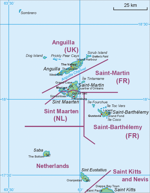
Anguilla is noted for its ecologically important coral reefs and beaches. Apart from the main island of Anguilla itself, the territory includes a number of other smaller islands and cays, mostly tiny and uninhabited:
- Anguillita
- Blowing Rock
- Dog Island
- Little Scrub Island
- Prickly Pear Cays
- Scrub Island
- Seal Island
- Sombrero, also known as Hat Island
- Sandy Island
- Scilly Cay

Economy:
Anguilla’s thin arid soil being largely unsuitable for agriculture, the island has few land-based natural resources. Its main industries are tourism, offshore incorporation and management, offshore banking, captive insurance and fishing.
Anguilla’s currency is the East Caribbean dollar, though the US dollar is also widely accepted. The exchange rate is fixed to the US dollar at US$1 = EC$2.70.
The economy, and especially the tourism sector, suffered a setback in late 1995 due to the effects of Hurricane Luis in September. Hotels were hit particularly hard but a recovery occurred the following year. Another economic setback occurred during the aftermath of Hurricane Lenny in 2000. Before the 2008 worldwide crisis, the economy of Anguilla was growing strongly, especially the tourism sector which was driving major new developments in partnerships with multi-national companies. Anguilla’s tourism industry received a major boost when it was selected to host the World Travel Awards in December 2014. Known as “the Oscars of the travel industry”, the awards ceremony was held at the CuisinArt Resort and Spa and was hosted by Vivica A. Fox. Anguilla was voted the World’s Leading Luxury Island Destination from a short list of top-tier candidates such as St. Barts, the Maldives and Mauritius.