Introduction:
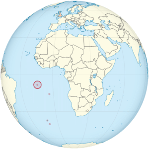
Ascension Island is an isolated volcanic island, 7°56′ south of the Equator in the South Atlantic Ocean. It is about 1,000 miles (1,600 km) from the coast of Africa and 1,400 miles (2,300 km) from the coast of Brazil. It is governed as part of the British Overseas Territory of Saint Helena, Ascension and Tristan da Cunha, of which the main island, Saint Helena, is around 800 miles (1,300 km) to the southeast. The territory also includes the sparsely populated Tristan da Cunha archipelago, 2,300 miles (3,700 km) to the south, about halfway to the Antarctic Circle.
Named after the day of its recorded discovery, Ascension of Jesus, Ascension Island was an important safe haven as a coaling station to mariners and a refueling stop for commercial airliners back in the days of international air travel by flying boats.
During World War II, it was an important naval and air station, especially providing antisubmarine warfare bases in the Battle of the Atlantic. Ascension Island was garrisoned by the British Admiralty from 22 October 1815 to 1922.

The island is the location of RAF Ascension Island, which is a Royal Air Force station, a European Space Agency rocket tracking station, an Anglo-American signals intelligence facility and the BBC World Service Atlantic Relay Station. The island was used extensively as a staging point by the British military during the Falklands War. Ascension Island hosts one of four ground antennas that assist in the operation of the Global Positioning System (GPS) navigational system (others are on Kwajalein Island, Diego Garcia, and Cape Canaveral). NASA operates a Meter Class Autonomous Telescope (MCAT) on Ascension Island for tracking orbital debris, which is potentially hazardous to operating spacecraft and astronauts, at a facility called the John Africano NASA/AFRL Orbital Debris Observatory.
History:
Discovery:
In 1501, the Portuguese navigator João da Nova sighted the island on Ascension Day (which fell on 21 May that year) and named it Ilha da Ascensão after this feast day. Dry and barren, the island had little appeal for passing ships except for collecting fresh meat, and was not claimed for the Portuguese Crown. Mariners could hunt for the numerous seabirds and the enormous female green turtles that laid their eggs on the sandy beaches. The Portuguese also introduced goats as a potential source of meat for future mariners.
In February 1701, HMS Roebuck, commanded by William Dampier, sank in the common anchoring spot in Clarence Bay to the northwest of the island. Sixty men survived for two months until they were rescued. Almost certainly, after a few days they found the strong water spring in the high interior of the island, in what is now called Breakneck Valley (there is a much smaller water source, lower on the mountain, which was named Dampier’s Drip by people who probably misinterpreted Dampier’s story).

It is possible that the island was sometimes used as an open prison for criminal mariners, although there is only one documented case of such an exile, a Dutch ship’s officer, Leendert Hasenbosch, set ashore at Clarence Bay as a punishment for sodomy in May 1725. British mariners found the Dutchman’s tent, belongings and diary in January 1726; the man’s remains were not found. His diary was published in translation in London later that same year, under the title Sodomy Punish’d.
Organized settlement:
Organized settlement of Ascension Island began in 1815, when the British garrisoned it as a precaution after imprisoning Napoleon on Saint Helena to the southeast. On 22 October the Cruizer-class brig-sloops Zenobia and Peruvian claimed the island for King George III. The Royal Navy designated the island as a stone frigate, HMS Ascension, with the classification of “Sloop of War of the smaller class”.
