
The 1820s saw further exploration in the Canberra area associated with the construction of a road from Sydney to the Goulburn plains. While working on the project, Charles Throsby learned of a nearby lake and river from the local Indigenous peoples and he accordingly sent Wild to lead a small party to investigate the site. The search was unsuccessful, but they did discover the Yass River and it is surmised that they would have set foot on part of the future territory.
A second expedition was mounted shortly thereafter and they became the first Europeans to camp at the Molonglo (Ngambri) and Queanbeyan (Jullergung) Rivers. However, they failed to find the Murrumbidgee River. The issue of the Murrumbidgee was solved in 1821 when Charles Throsby mounted a third expedition and successfully reached the watercourse, on the way providing the first detailed account of the land where Canberra now resides.
The last expedition in the region prior to settlement was undertaken by Allan Cunningham in 1824. He reported that the region was suitable for grazing and the settlement of the Limestone Plains followed immediately thereafter.
Early Settlement:
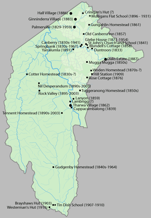
The first land grant in the region was made to Joshua John Moore in 1823 and European settlement in the area began in 1824 with the construction of a homestead by his stockmen on what is now the Acton Peninsula. Moore formally purchased the site in 1826 and named the property Canberry or Canberra.
A significant influx of population and economic activity occurred around the 1850s gold rushes. The gold rushes prompted the establishment of communication between Sydney and the region by way of the Cobb & Co coaches, which transported mail and passengers. The first post offices opened in Ginninderra in 1859 and at Lanyon in 1860.
During colonial times, the European communities of Ginninderra, Molonglo and Tuggeranong settled and farmed the surrounding land. The region was also called the Queanbeyan-Yass district, after the two largest towns in the area. The villages of Ginninderra and Tharwa developed to service the local agrarian communities.
During the first 20 years of settlement, there was only limited contact between the settlers and Aboriginal people. Over the succeeding years, the Ngunnawal and other local indigenous people effectively ceased to exist as cohesive and independent communities adhering to their traditional ways of life. Those who had not succumbed to disease and other predations either dispersed to the local settlements or were relocated to more distant Aboriginal reserves set up by the New South Wales government in the latter part of the 19th century.
Creation of the Territory:
In 1898, a referendum on a proposed Constitution was held in four of the colonies – New South Wales, Victoria, South Australia and Tasmania. Although the referendum achieved a majority in all four colonies, the New South Wales referendum failed to gain the minimum number of votes needed for the bill to pass. Following this result, a meeting of the four Premiers in 1898 heard from George Reid, the Premier of New South Wales, who argued that locating the future capital in New South Wales would be sufficient to ensure the passage of the Bill. The 1899 referendum on this revised bill was successful and passed with sufficient numbers. Section 125 of the Australian Constitution thus provided that, following Federation in 1901, land would be ceded freely to the new Federal Government.