
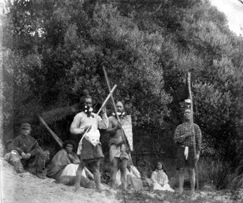
The incoming Māori were received and initially cared for by the local Moriori. Soon, Ngāti Mutunga and Ngāti Tama began to takahi, or walk the land, to lay claim to it. When it became clear that the visitors intended to stay, the Moriori withdrew to their marae at te Awapatiki. There, after holding a hui (consultation) to debate what to do about the Māori settlers, the Moriori decided to keep with their policy of non-aggression.
Ngāti Mutunga and Ngāti Tama in turn saw the meeting as a precursor to warfare on the part of Moriori and responded. The Māori attacked and in the ensuing action killed over 260 Moriori.
1880s to Today:
The economy of the Chatham Islands, then dominated by the export of wool, suffered under the international depression of the 1880s, only rebounding with the building of fish freezing plants at the island villages of Ōwenga and Kaingaroa in 1910. Construction of the first wharf at Waitangi began in 1931 with completion in 1934. On 25 November 1940, during the Second World War, a German raider captured and then sank the Chatham Islands supply ship, the Holmwood, so the wharf saw little use by ships. A flying-boat facility was built soon after at Te Whanga Lagoon and a flying boat service continued till 1966 when it was replaced with conventional aircraft.
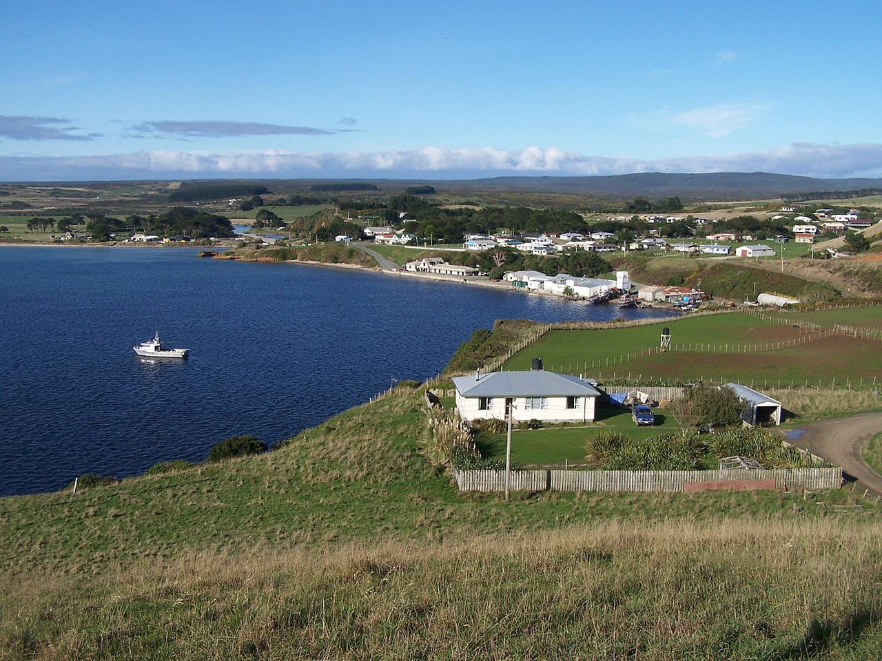
After the Second World War, the island economy suffered again due to its isolation and government subsidies became necessary. This led to many young Chatham Islanders leaving for the mainland. There was a brief crayfish boom which helped stabilize the economy in the late 1960s and early 1970s. From the early 2000s cattle became a major component of the local economy.
Geography:
The islands lie roughly 840 kilometers (520 mi) east of Christchurch, New Zealand. The nearest New Zealand mainland point to the Chatham Islands, Cape Turnagain in the North Island, is 650 kilometers (400 mi) distant. The two largest islands, Chatham Island and Pitt Island, constitute most of the total area of 966 square kilometers (373 sq mi), with a dozen scattered islets making up the rest.
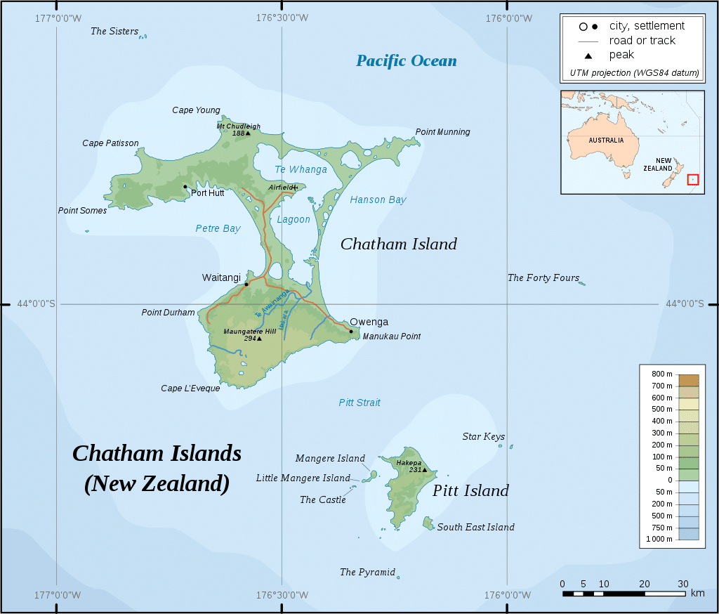
The islands sit on the Chatham Rise, a large, relatively shallowly submerged (no more than 1,000 meters or 3,281 feet deep at any point) part of the Zealandia continent that stretches east from near the South Island. The Chatham Islands, which emerged only within the last four million years, are the only part of the Chatham Rise showing above sea level.
The islands are hilly, with coastal areas including cliffs, dunes, beaches, and lagoons. Pitt is more rugged than Chatham; its highest point (299 meters or 981 feet) is on a plateau near the southernmost point of the main island, 1.5 kilometers (0.93 mi) south of Lake Te Rangatapu. The plateau is dotted with numerous lakes and lagoons, flowing mainly from the island’s nearby second-highest point, Maungatere Hill, at 294 meters. Notable are the large Te Whanga Lagoon, and Huro and Rangitahi. Chatham has a number of streams, including Te Awainanga and Tuku.