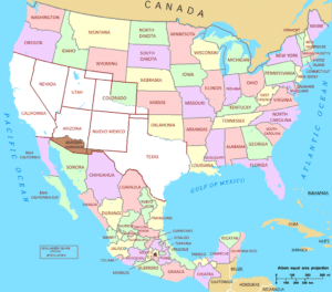
The Spanish Empire claimed Colorado as part of its New Mexico province prior to U.S. involvement in the region. The U.S. acquired a territorial claim to the eastern Rocky Mountains with the Louisiana Purchase from France in 1803. This U.S. claim conflicted with the claim by Spain to the upper Arkansas River Basin as the exclusive trading zone of its colony of Santa Fé de Nuevo México. In 1806, Zebulon Pike led a U.S. Army reconnaissance expedition into the disputed region. Colonel Pike and his men were arrested by Spanish cavalrymen in the San Luis Valley the following February, taken to Chihuahua, and expelled from Mexico the following July.
The U.S. relinquished its claim to all land south and west of the Arkansas River and south of 42nd parallel north and west of the 100th meridian west as part of its purchase of Florida from Spain with the Adams-Onís Treaty of 1819. The treaty took effect February 22, 1821. Having settled its border with Spain, the U.S. admitted the southeastern portion of the Territory of Missouri to the Union as the state of Missouri on August 10, 1821. The remainder of Missouri Territory, including what would become northeastern Colorado, became unorganized territory, and remained so for 33 years over the question of slavery. After 11 years of war, Spain finally recognized the independence of Mexico with the Treaty of Córdoba signed on August 24, 1821. Mexico eventually ratified the Adams-Onís Treaty in 1831. The Texian Revolt of 1835–36 fomented a dispute between the U.S. and Mexico which eventually erupted into the Mexican–American War in 1846. Mexico surrendered its northern territory to the U.S. with the Treaty of Guadalupe Hidalgo at the conclusion of the war in 1848.

Most American settlers traveling overland west to the Oregon Country, namely the new goldfields of California, or the new Mormon settlements of the State of Deseret in the Salt Lake Valley, avoided the rugged Southern Rocky Mountains, and instead followed the North Platte River and Sweetwater River to South Pass (Wyoming), the lowest crossing of the Continental Divide between the Southern Rocky Mountains and the Central Rocky Mountains. In 1849, the Mormons of the Salt Lake Valley organized the extralegal State of Deseret, claiming the entire Great Basin and all lands drained by the rivers Green, Grand, and Colorado. The federal government of the U.S. flatly refused to recognize the new Mormon government, because it was theocratic and sanctioned plural marriage. Instead, the Compromise of 1850 divided the Mexican Cession and the northwestern claims of Texas into a new state and two new territories, the state of California, the Territory of New Mexico, and the Territory of Utah. On April 9, 1851, Mexican American settlers from the area of Taos settled the village of San Luis, then in the New Mexico Territory, later to become Colorado’s first permanent Euro-American settlement.
Territory Act:
On February 28, 1861, outgoing U.S. President James Buchanan signed an Act of Congress organizing the free Territory of Colorado. The original boundaries of Colorado remain unchanged today. The name Colorado was chosen because it was commonly believed that the Colorado River originated in the territory. In 1776, Spanish priest Silvestre Vélez de Escalante recorded that Native Americans in the area knew the river as el Rio Colorado for the red-brown silt that the river carried from the mountains. In 1859, a U.S. Army topographic expedition led by Captain John Macomb located the confluence of the Green River with the Grand River in what is now Canyonlands National Park in Utah. The Macomb party designated the confluence as the source of the Colorado River.
