

The Charyn Canyon is 80 kilometres (50 mi) long, cutting through a red sandstone plateau and stretching along the Charyn River gorge in northern Tian Shan. The steep canyon slopes, columns and arches rise to heights of between 150 and 300 metres (490 and 980 feet). The inaccessibility of the canyon provided a safe haven for a rare ash tree, Fraxinus sogdiana, which survived the Ice Age there and is now also grown in some other areas. Bigach crater is a Pliocene or Miocene asteroid impact crater, 8 km (5 mi) in diameter and estimated to be 5±3 million years old.
Economy:
Kazakhstan has the largest and strongest performing economy in Central Asia. Supported by rising oil output and prices, Kazakhstan’s economy grew at an average of 8% per year until 2013, before suffering a slowdown in 2014 and 2015. Kazakhstan was the first former Soviet Republic to repay all of its debt to the International Monetary Fund, 7 years ahead of schedule.
Kazakhstan has a GDP of $179.332 billion and an annual growth rate of 4.5%. Per capita, Kazakhstan’s GDP stands at $9,686.
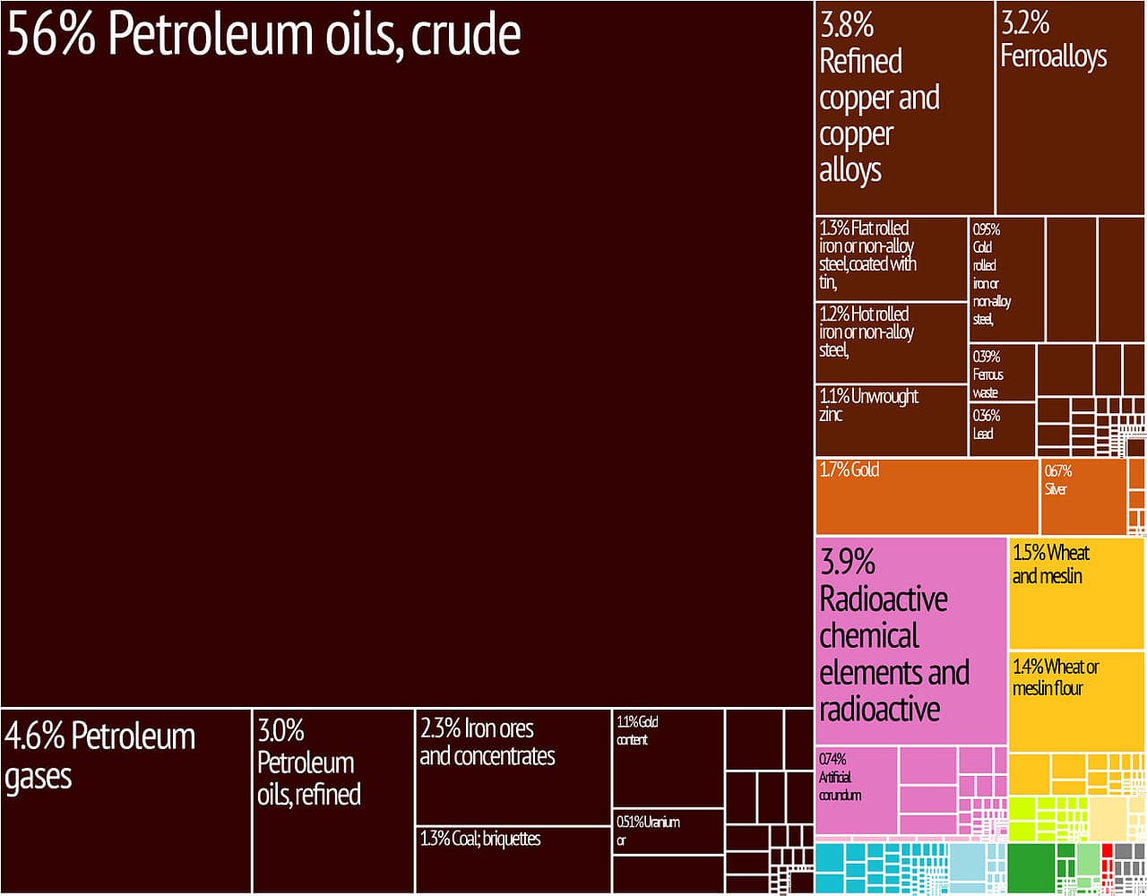
Kazakhstan ranks third, after China and Qatar, among the 25 most dynamic economies of the 21st century’s first decade. Kazakhstan’s increased role in global trade and central positioning on the new Silk Road has given the country the potential to open its markets to billions of people. Kazakhstan joined the World Trade Organisation in 2015.
Buoyed by high world crude oil prices, GDP growth figures were between 8.9% and 13.5% from 2000 to 2007 before decreasing to 1–3% in 2008 and 2009, and then rising again from 2010. Other major exports of Kazakhstan include wheat, textiles, and livestock. Kazakhstan is a leading exporter of uranium.
Transportation:
Kazakhstan is committed to regional infrastructure development. According to the Kazakhstan Ambassador to the U.S., Kairat Umarov, Kazakhstan invested $18 billion in construction of airports, highways, and railroads in 2014.
Railways provide 68% of all cargo and passenger traffic to over 57% of the country. There are 15,333 km (9,527 mi) in common carrier service, excluding industrial lines. All railway lines in Kazakhstan are built in 1,520 mm (4 ft 11 27⁄32 in) gauge, of which 4,000 km (2,500 mi) is electrified (2012).
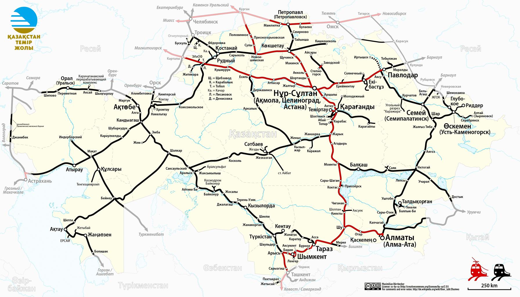
Kazakhstan Temir Zholy (KTZ) is the national railway company. KTZ cooperates with French loco manufacturer Alstom in developing Kazakhstan’s railway infrastructure. Alstom has more than 600 staff and two joint ventures with KTZ and its subsidiary in Kazakhstan. In July 2017, Alstom opened its first locomotive repairing center in Kazakhstan. It is the only repairing center in Central Asia and the Caucasus.
As the Kazakhstani rail system was designed during the Soviet era, rail routes were designed ignoring inter-Soviet borders, based on the needs of Soviet planning. This has caused anomalies, such as the route from Oral to Aktobe passing briefly through Russian territory. It also means that routes might not suit modern-day Kazakhstani needs.