
Although there were fears of electoral fraud in Mexico’s 2018 presidential elections, the results gave a mandate to AMLO. Mexico’s literacy rate is high, at 94.86% in 2018, up from 82.99% in 1980, with the literacy rates of males and females being relatively equal.
During the COVID-19 pandemic, as of mid-March, the country had a few cases, but as of mid-July, there were over 320,000 cases reported.
Geography:
Almost all of Mexico lies in the North American Plate, with small parts of the Baja California peninsula on the Pacific and Cocos Plates. Geophysically, some geographers include the territory east of the Isthmus of Tehuantepec (around 12% of the total) within Central America. Geopolitically, however, Mexico is entirely considered part of North America, along with Canada and the United States.
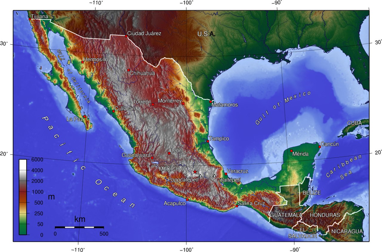
Mexico’s total area is 1,972,550 km2 (761,606 sq mi), making it the world’s 13th largest country by total area. It has coastlines on the Pacific Ocean and Gulf of California, as well as the Gulf of Mexico and Caribbean Sea, the latter two forming part of the Atlantic Ocean. Within these seas are about 6,000 km2 (2,317 sq mi) of islands (including the remote Pacific Guadalupe Island and the Revillagigedo Islands). From its farthest land points, Mexico is a little over 2,000 mi (3,219 km) in length.
On its north, Mexico shares a 3,141 km (1,952 mi) border with the United States. The meandering Río Bravo del Norte (known as the Rio Grande in the United States) defines the border from Ciudad Juárez east to the Gulf of Mexico. A series of natural and artificial markers delineate the United States-Mexican border west from Ciudad Juárez to the Pacific Ocean. On its south, Mexico shares an 871 km (541 mi) border with Guatemala and a 251 km (156 mi) border with Belize.
Mexico is crossed from north to south by two mountain ranges known as Sierra Madre Oriental and Sierra Madre Occidental, which are the extension of the Rocky Mountains from northern North America. From east to west at the center, the country is crossed by the Trans-Mexican Volcanic Belt also known as the Sierra Nevada. A fourth mountain range, the Sierra Madre del Sur, runs from Michoacán to Oaxaca.

As such, the majority of the Mexican central and northern territories are located at high altitudes, and the highest elevations are found at the Trans-Mexican Volcanic Belt: Pico de Orizaba (5,700 m or 18,701 ft), Popocatépetl (5,462 m or 17,920 ft) and Iztaccihuatl (5,286 m or 17,343 ft) and the Nevado de Toluca (4,577 m or 15,016 ft). Three major urban agglomerations are located in the valleys between these four elevations: Toluca, Greater Mexico City and Puebla.
Economy:
As of April 2018, Mexico has the 15th largest nominal GDP (US$1.15 trillion) and the 11th largest by purchasing power parity (US$2.45 trillion). GDP annual average growth was 2.9% in 2016 and 2% in 2017. Agriculture has comprised 4% of the economy over the last two decades, while industry contributes 33% (mostly automotive, oil, and electronics) and services (notably financial services and tourism) contribute 63%. Mexico’s GDP in PPP per capita was US$18,714.05.