Introduction:
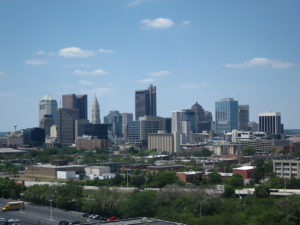
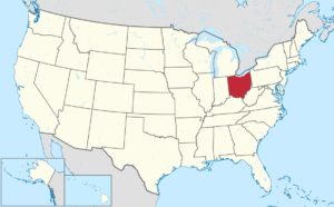
Ohio is a Midwestern state in the Great Lakes region of the United States. Ohio is the 34th largest by area, the 7th most populous, and the 10th most densely populated of the 50 United States. The state’s capital and largest city is Columbus.

The state takes its name from the Ohio River. The name originated from the Seneca language word ohiːyo’, meaning “great river” or “large creek”. Partitioned from the Northwest Territory, the state was admitted to the Union as the 17th state on March 1, 1803.
Geography:
Ohio’s neighbors are Pennsylvania to the east, Michigan to the northwest, Lake Erie to the north, Indiana to the west, Kentucky on the south, and West Virginia on the southeast.

Ohio is bounded by the Ohio River, but nearly all of the river itself belongs to Kentucky and West Virginia. In 1980, the U.S. Supreme Court held that, based on the wording of the cessation of territory by Virginia, which at that time included what is now Kentucky and West Virginia, the boundary between Ohio and Kentucky, and, by implication, West Virginia, is the northern low-water mark of the river as it existed in 1792. Ohio has only that portion of the river between the river’s 1792 low-water mark and the present high-water mark.
The border with Michigan has also changed, as a result of the Toledo War, to angle slightly northeast to the north shore of the mouth of the Maumee River.
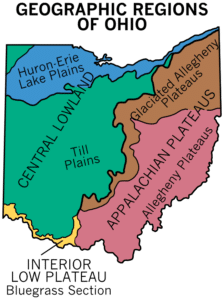
Much of Ohio features glaciated till plains, with an exceptionally flat area in the northwest being known as the Great Black Swamp. This glaciated region in the northwest and central state is bordered to the east and southeast first by a belt known as the glaciated Allegheny Plateau, and then by another belt known as the unglaciated Allegheny Plateau. Most of Ohio is of low relief, but the unglaciated Allegheny Plateau features rugged hills and forests.

The rugged southeastern quadrant of Ohio, stretching in an outward bow-like arc along the Ohio River from the West Virginia Panhandle to the outskirts of Cincinnati, forms a distinct socio-economic unit. Geologically similar to parts of West Virginia and southwestern Pennsylvania, this area’s coal mining legacy, dependence on small pockets of old manufacturing establishments, and distinctive regional dialect set this section off from the rest of the state.
History:
Archeological evidence suggests that the Ohio Valley was inhabited by nomadic people as early as 13,000 BC. These early nomads disappeared from Ohio by 1,000 BC. Between 1,000 and 800 BC, the sedentary Adena culture emerged. The Adena were able to establish “semi-permanent” villages because they domesticated plants, which included squash, sunflowers, and perhaps corn. Cultivation of these in addition to hunting and gathering supported more settled, complex villages. The most spectacular remnant of the Adena culture is the Great Serpent Mound, located in Adams County, Ohio.

