
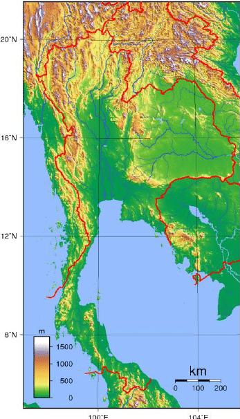
Southern Thailand consists of the narrow Kra Isthmus that widens into the Malay Peninsula. Politically, there are six geographical regions which differ from the others in population, basic resources, natural features, and level of social and economic development. The diversity of the regions is the most pronounced attribute of Thailand’s physical setting.
The Chao Phraya and the Mekong River are the indispensable water courses of rural Thailand. Industrial scale production of crops use both rivers and their tributaries. The Gulf of Thailand covers 320,000 square kilometers (124,000 sq mi) and is fed by the Chao Phraya, Mae Klong, Bang Pakong, and Tapi Rivers. It contributes to the tourism sector owing to its clear shallow waters along the coasts in the southern region and the Kra Isthmus. The eastern shore of the Gulf of Thailand is an industrial center of Thailand with the kingdom’s premier deepwater port in Sattahip and its busiest commercial port, Laem Chabang.
The Andaman Sea is a precious natural resource as it hosts popular and luxurious resorts. Phuket, Krabi, Ranong, Phang Nga and Trang, and their islands, all lay along the coasts of the Andaman Sea and, despite the 2004 tsunami, they remain a tourist magnet.
Economy:
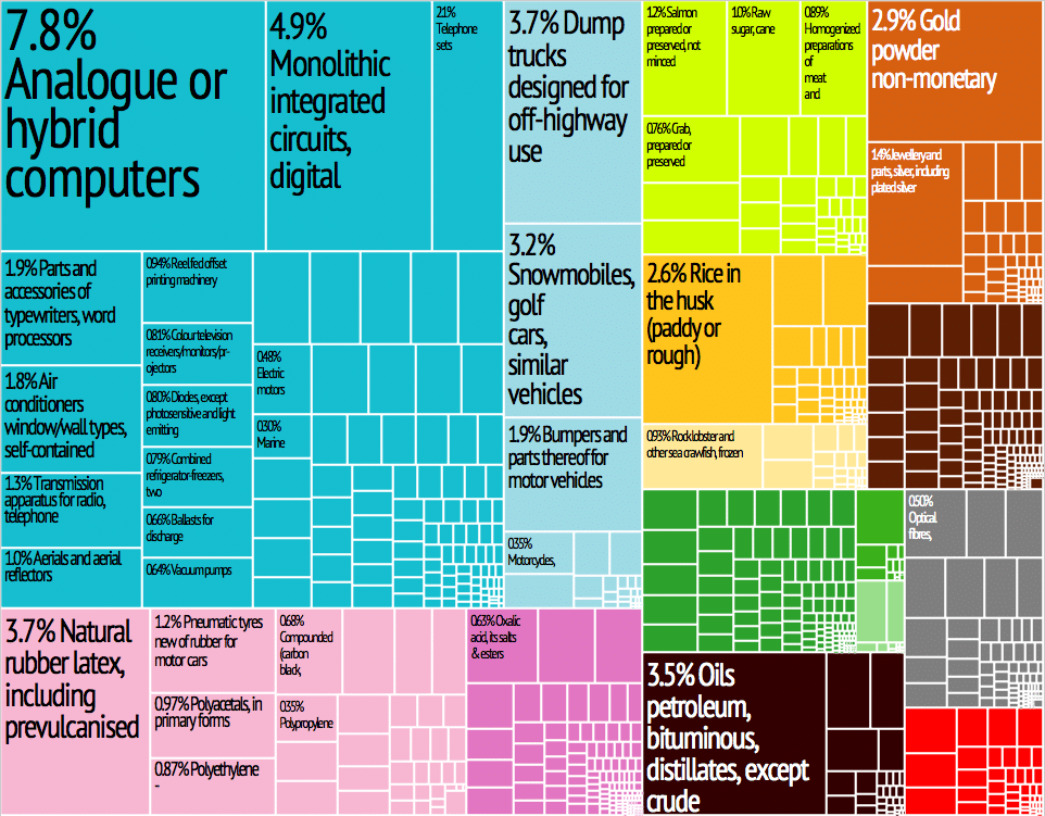
The economy of Thailand is heavily export-dependent, with exports accounting for more than two-thirds of gross domestic product (GDP). Thailand exports over US$105 billion worth of goods and services annually. Major exports include cars, computers, electrical appliances, rice, textiles and footwear, fishery products, rubber, and jewelry.
Thailand is an emerging economy and is considered a newly industrialized country. Thailand had a 2017 GDP of US$1.236 trillion (on a purchasing power parity basis). Thailand is the 2nd largest economy in Southeast Asia after Indonesia. Thailand ranks midway in the wealth spread in Southeast Asia as it is the 4th richest nation according to GDP per capita, after Singapore, Brunei, and Malaysia.
Thailand functions as an anchor economy for the neighboring developing economies of Laos, Myanmar, and Cambodia. In the third quarter of 2014, the unemployment rate in Thailand stood at 0.84% according to Thailand’s National Economic and Social Development Board (NESDB).
Transportation:
The State Railway of Thailand (SRT) operates all of Thailand’s national rail lines. Bangkok Railway Station (Hua Lamphong Station) is the main terminus of all routes. Phahonyothin and ICD Lat Krabang are the main freight terminals. As of 2017 SRT had 4,507 km (2,801 mi) of track, all of it meter gauge except the Airport Link. Nearly all is single-track (4,097 km), although some important sections around Bangkok are double (303 km or 188 mi) or triple-tracked (107 km or 66 mi) and there are plans to extend this. Rail transport in Bangkok includes long-distance services, and some daily commuter trains running from and to the outskirts of the city during the rush hour, but passenger numbers have remained low. There are also three rapid transit rail systems in the capital.
Thailand has 390,000 kilometers (240,000 miles) of highways. According to the BBC Thailand has 462,133 roads and many multi-lane highways. As of 2017 Thailand has 37 million registered vehicles, 20 million of them motorbikes. A number of undivided two-lane highways have been converted into divided four-lane highways. A Bangkok – Chon Buri motorway (Route 7) now links to the new airport and Eastern Seaboard. There are 4,125 public vans operating on 114 routes from Bangkok alone. Other forms of road transport includes tuk-tuks, taxis—as of November 2018, Thailand has 80,647 registered taxis nationwide—vans (minibus), motorbike taxis and songthaews.