Introduction:
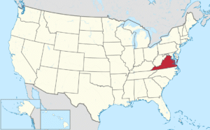
Virginia, officially known as the Commonwealth of Virginia, one of four Commonwealth (Kentucky, Massachusetts, Pennsylvania being the other) states in the United States, is a state in the, depending on where you draw the completely artificial lines, Southeastern or Mid-Atlantic region of the United States. Virginia is located between the Atlantic Coast and the Appalachian Mountains. Virginia holds claim to the title of the first colonial possession of Great Britain in what is now the United States.

Geography:
Virginia is the 35th-largest state by area.
Virginia is bordered to the north and east by Maryland and Washington, D.C.; to the east by the Atlantic Ocean; to the south by North Carolina; to the southwest by Tennessee; to the west by Kentucky; and to the north and west by West Virginia.
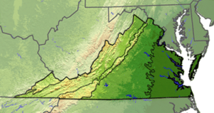
Traditionally Virginia is divided into five regions based on both geography and geology which are from east to west: Tidewater, Piedmont, Blue Ridge Mountains, Ridge and Valley, and Cumberland Plateau.

The Tidewater is a coastal plain between the Atlantic coast and the fall line. The Piedmont is a series of sedimentary and igneous rock-based foothills east of the mountains which were formed in the Mesozoic era. The Blue Ridge Mountains are a part of the Appalachian Mountains with the highest point in the state tallest being Mount Rogers at 5,729 feet.

The Ridge and Valley region is west of the mountains and includes the Great Appalachian Valley. The Cumberland Plateau and the Cumberland Mountains are in the southwest corner of Virginia, south of the Allegheny Plateau.
History:
Human habitation in what is now Virginia for at least 12,000 years ago. By 5,000 years ago more permanent settlements emerged, and farming began by 900 AD. By 1500, the Algonquian peoples had founded towns in the Tidewater region. In 1607, the native Tidewater population was between 13,000 and 14,000.
Several European expeditions, including a group of Spanish Jesuits, explored the Chesapeake Bay during the 16th century. In 1583, Queen Elizabeth I of England granted Walter Raleigh a charter to plant a colony north of Spanish Florida. In 1584, Raleigh sent an expedition to the Atlantic coast of North America. The name “Virginia” may have been suggested then by Raleigh or Elizabeth, perhaps noting her status as the “Virgin Queen.” Initially the name applied to the entire coastal region from South Carolina to Maine, plus the island of Bermuda. Later, subsequent royal charters modified the Colony’s boundaries. The London Company was incorporated as a joint stock company by the proprietary Charter of 1606, which granted land rights to this area. The company financed the first permanent English settlement in the “New World”, Jamestown. Named for King James I, it was founded in May 1607. With the bankruptcy of the London Company in 1624, the settlement was taken into royal authority as an English crown colony.

Life in the colony was perilous, and many died during the early 17th century. By 1624, only 3,400 of the 6,000 early settlers had survived. However, European demand for tobacco fueled the arrival of more settlers and servants.
