Introduction:
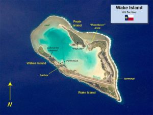
Wake Island (also known as Wake Atoll) is a coral atoll in the western Pacific Ocean in the northeastern area of the Micronesia subregion, 1,501 miles east of Guam, 2,298 miles west of Honolulu and 1,991 miles southeast of Tokyo. The island is an unorganized, unincorporated territory of the United States that is also claimed by the Republic of the Marshall Islands. Wake Island is one of the most isolated islands in the world and the nearest inhabited island is Utirik Atoll in the Marshall Islands, 592 miles to the southeast.
Wake Island is administered by the United States Air Force under an agreement with the U.S. Department of the Interior. The center of activity on the atoll is at Wake Island Airfield, which is primarily used as a mid-Pacific refueling stop for military aircraft and an emergency landing area. The 9,800-foot runway is the longest strategic runway in the Pacific islands. South of the runway is the Wake Island Launch Center, a missile launch site of the Ronald Reagan Ballistic Missile Defense Test Site operated by the United States Army Space and Missile Defense Command and the Missile Defense Agency. The Base Operations Support contractor at Wake is Chugach Federal Solutions, Inc. About 94 people live on the island, and access to it is restricted. Population fluctuates depending on operations being conducted by Missile Defense Agency activities.

On December 11, 1941, Wake Island was the site of the Empire of Japan‘s first unsuccessful attack on American forces in the Battle of Wake Island when U.S. Marines, with some US Navy personnel and civilians on the island repelled an attempted Japanese invasion, sinking two enemy destroyers and a transport. The island fell to overwhelming Japanese forces 12 days later in a second attack, this one with extensive support from Japanese carrier-based aircraft returning from the attack on Pearl Harbor naval and air bases in Hawaii further east, four days previously. Wake Island remained occupied by Japanese forces until the end of the war in September 1945.
The submerged and emergent lands at the atoll are a unit of the Pacific Remote Islands Marine National Monument.
Etymology:
Wake Island derives its name from British sea captain Samuel Wake, who rediscovered the atoll in 1796 while in command of the Prince William Henry. The name is sometimes attributed to Capt. William Wake, who also is reported to have discovered the atoll from the Prince William Henry in 1792.
Geography:
Island Acres
Wake Islet 1,367.04
Wilkes Islet 197.44
Peale Islet 256.83
Wake Island 1,821.31
Lagoon (water) 1,480.00
Sand Flat 910.00
Wake is located two-thirds of the way from Honolulu to Guam. Honolulu is 2,300 statute miles to the east and Guam 1,510 statute miles to the west. The closest land is the uninhabited Bokak Atoll, 348, miles in the Marshall Islands to the southeast. The atoll is to the west of the International Date Line and in the Wake Island Time Zone (UTC+12), the easternmost time zone in the United States, and almost one day ahead of the 50 states.
