
Tourist literature describes Cameroon as “Africa in miniature” because it exhibits all major climates and vegetation of the continent: coast, desert, mountains, rainforest, and savanna.
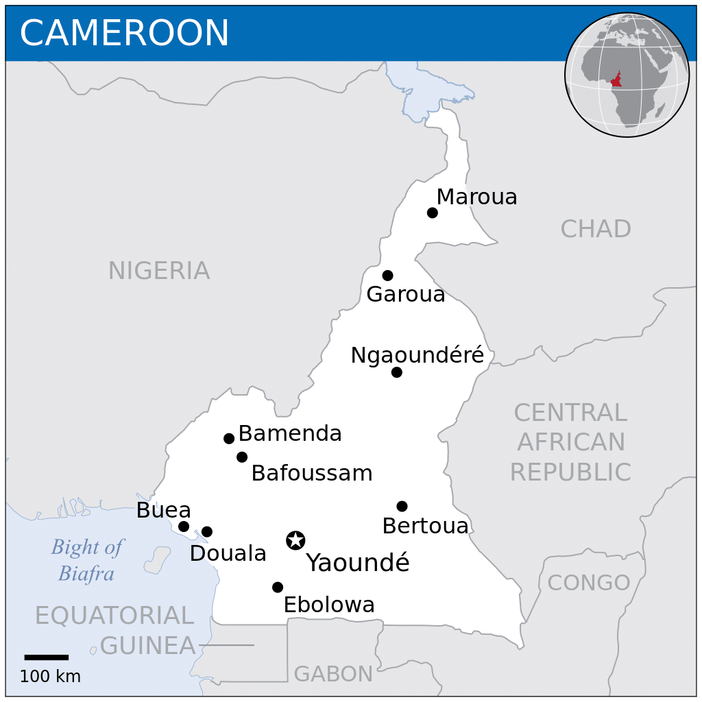
Cameroon is divided into five major geographic zones distinguished by dominant physical, climatic, and vegetative features. The coastal plain extends 9 to 93 miles inland from the Gulf of Guinea and has an average elevation of 295 feet. Exceedingly hot and humid with a short dry season, this belt is densely forested and includes some of the wettest places on earth, part of the Cross-Sanaga-Bioko coastal forests.
The South Cameroon Plateau rises from the coastal plain to an average elevation of 2,133 feet. Equatorial rain-forest dominates this region, although its alternation between wet and dry seasons makes it is less humid than the coast. This area is part of the Atlantic Equatorial coastal forests eco-region.
An irregular chain of mountains, hills, and plateaus known as the Cameroon range extends from Mount Cameroon on the coast—Cameroon’s highest point at 13,435 feet almost to Lake Chad at Cameroon’s northern border. This region has a mild climate, particularly on the Western High Plateau, although rainfall is high. Its soils are among Cameroon’s most fertile, especially around volcanic Mount Cameroon. Volcanism here has created crater lakes. On 21 August 1986, one of these, Lake Nyos, belched carbon dioxide and killed between 1,700 and 2,000 people. This area has been delineated by the World Wildlife Fund as the Cameroonian Highlands forests eco-region.
The southern plateau rises northward to the grassy, rugged Adamawa Plateau. This feature stretches from the western mountain area and forms a barrier between the country’s north and south. Its average elevation is 3,609 feet with high rainfall between April and October peaking in July and August. The northern lowland region extends from the edge of the Adamawa to Lake Chad with an average elevation of 984 to 1,148 feet). Its characteristic vegetation is savanna scrub and grass. This is an arid region with sparse rainfall and high median temperatures.
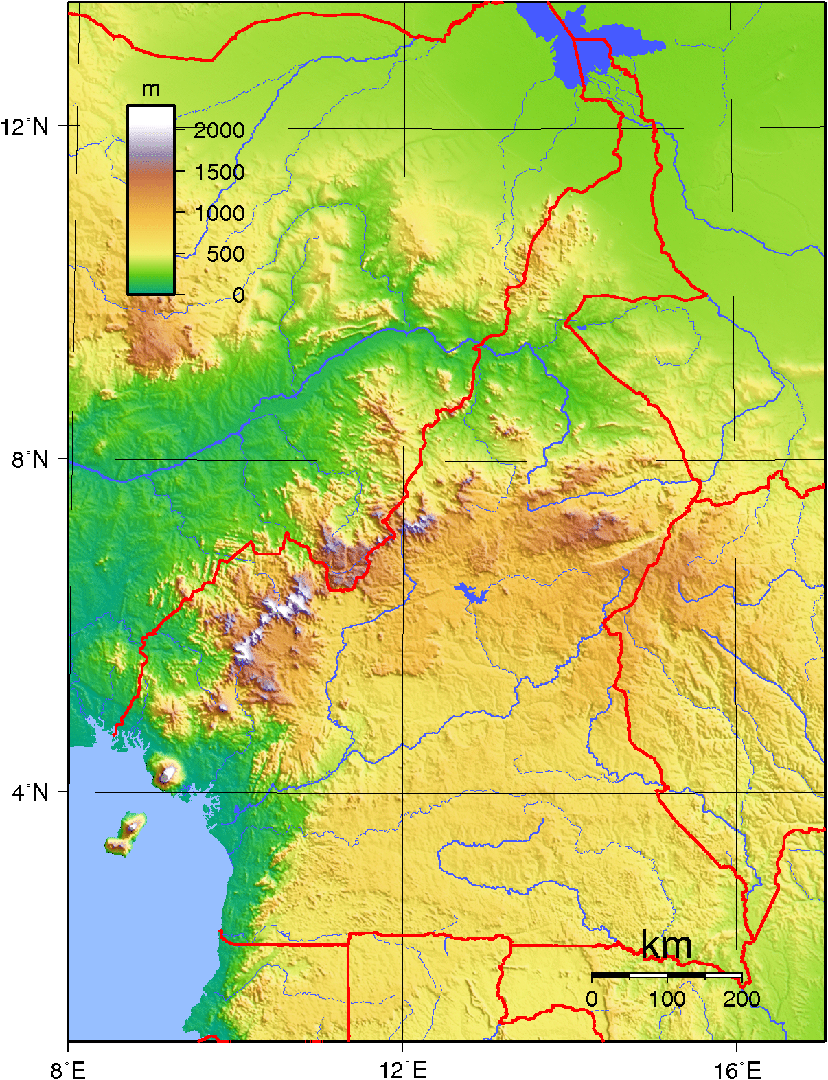
Cameroon has four patterns of drainage. In the south, the principal rivers are the Ntem, Nyong, Sanaga, and Wouri. These flow southwestward or westward directly into the Gulf of Guinea. The Dja and Kadéï drain southeastward into the Congo River. In northern Cameroon, the Bénoué River runs north and west and empties into the Niger. The Logone flows northward into Lake Chad, which Cameroon shares with three neighboring countries.
Economy:
Cameroon’s per-capita GDP (Purchasing power parity) was estimated as US$2,300 in 2008, one of the ten highest in sub-Saharan Africa. Major export markets include France, Italy, South Korea, Spain, and the United Kingdom. Cameroon is aiming to become an emerging country by 2035.
Cameroon’s natural resources are very well suited to agriculture and arboriculture. An estimated 70% of the population farms, and agriculture comprised an estimated 19.8% of GDP in 2009. Most agriculture is done at the subsistence scale by local farmers using simple tools. They sell their surplus produce, and some maintain separate fields for commercial use. Urban centers are particularly reliant on peasant agriculture for their foodstuffs. Soils and climate on the coast encourage extensive commercial cultivation of bananas, cocoa, oil palms, rubber, and tea. Inland on the South Cameroon Plateau, cash crops include coffee, sugar, and tobacco. Coffee is a major cash crop in the western highlands, and in the north, natural conditions favor crops such as cotton, groundnuts, and rice. Reliance on agricultural exports makes Cameroon vulnerable to shifts in their prices.