Algeria held elections in 1999, considered biased by international observers and most opposition groups which were won by President Abdelaziz Bouteflika. He worked to restore political stability to the country and announced a “Civil Concord” initiative, approved in a referendum, under which many political prisoners were pardoned, and several thousand members of armed groups were granted exemption from prosecution under a limited amnesty, in force until 13 January 2000. The AIS disbanded and levels of insurgent violence fell rapidly. The Groupe Salafiste pour la Prédication et le Combat (GSPC), a splinter group of the Group Islamic Army, continued a terrorist campaign against the Government.
Bouteflika was re-elected in the April 2004 presidential election after campaigning on a program of national reconciliation. The program comprised economic, institutional, political and social reform to modernise the country, raise living standards, and tackle the causes of alienation. It also included a second amnesty initiative, the Charter for Peace and National Reconciliation, which was approved in a referendum in September 2005. It offered amnesty to most guerrillas and Government security forces.

In November 2008, the Algerian Constitution was amended following a vote in Parliament, removing the two-term limit on Presidential incumbents. This change enabled Bouteflika to stand for re-election in the 2009 presidential elections, and he was re-elected in April 2009. During his election campaign and following his re-election, Bouteflika promised to extend the programme of national reconciliation and a $150-billion spending programme to create three million new jobs, the construction of one million new housing units, and to continue public sector and infrastructure modernisation programmes.
A continuing series of protests throughout the country started on 28 December 2010, inspired by similar protests across the Middle East and North Africa. On 24 February 2011, the government lifted Algeria’s 19-year-old state of emergency. The government enacted legislation dealing with political parties, the electoral code, and the representation of women in elected bodies. In April 2011, Bouteflika promised further constitutional and political reform. However, elections are routinely criticized by opposition groups as unfair and international human rights groups say that media censorship and harassment of political opponents continue.
Geography:
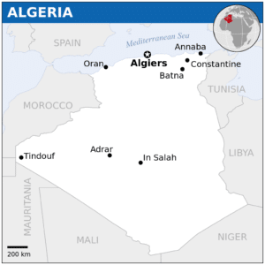
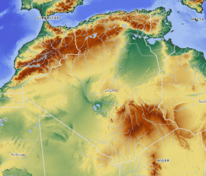
Algeria is the largest country in Africa, and the Mediterranean Basin. Its southern part includes a significant portion of the Sahara. To the north, the Tell Atlas form with the Saharan Atlas, further south, two parallel sets of reliefs in approaching eastbound, and between which are inserted vast plains and highlands. Both Atlas tend to merge in eastern Algeria. The vast mountain ranges of Aures and Nememcha occupy the entire northeastern Algeria and are delineated by the Tunisian border. The highest point is Mount Tahat (3,003 m).
Most of the coastal area is hilly, sometimes even mountainous, and there are a few natural harbours. The area from the coast to the Tell Atlas is fertile. South of the Tell Atlas is a steppe landscape ending with the Saharan Atlas; farther south, there is the Sahara desert.

