
Immediately following the November 1980 coup in Guinea-Bissau, relations between Cabo Verde and Guinea-Bissau became strained. Cabo Verde abandoned its hope for unity with Guinea-Bissau and formed the African Party for the Independence of Cabo Verde (PAICV). Problems have since been resolved and relations between the countries are good. The PAICV and its predecessor established a one-party system and ruled Cabo Verde from independence until 1990.
Responding to growing pressure for pluralistic democracy, the PAICV called an emergency congress in February 1990 to discuss proposed constitutional changes to end one-party rule. Opposition groups came together to form the Movement for Democracy (MPD) in Praia in April 1990. Together, they campaigned for the right to contest the presidential election scheduled for December 1990.
The one-party state was abolished 28 September 1990, and the first multi-party elections were held in January 1991. The MPD won a majority of the seats in the National Assembly, and MPD presidential candidate António Mascarenhas Monteiro defeated the PAICV’s candidate with 73.5% of the votes. Legislative elections in December 1995 increased the MPD majority in the National Assembly. The party won 50 of the National Assembly’s 72 seats.
A February 1996 presidential election returned President Monteiro to office. Legislative elections in January 2001 returned power to the PAICV, with the PAICV holding 40 of the National Assembly seats, MPD 30, and Party for Democratic Convergence (PCD) and Labour and Solidarity Party (PTS) 1 each. In February 2001, the PAICV-supported presidential candidate Pedro Pires defeated former MPD leader Carlos Veiga by only 13 votes.
Geography:
The Cabo Verde archipelago is in the Atlantic Ocean, approximately 570 kilometers (350 mi) off the western coast of the African continent, near Senegal, The Gambia, and Mauritania, and is part of the Macaronesia ecoregion.
The country is a horseshoe-shaped cluster of ten islands (nine inhabited) and eight islets, that constitute an area of 4033 km2.
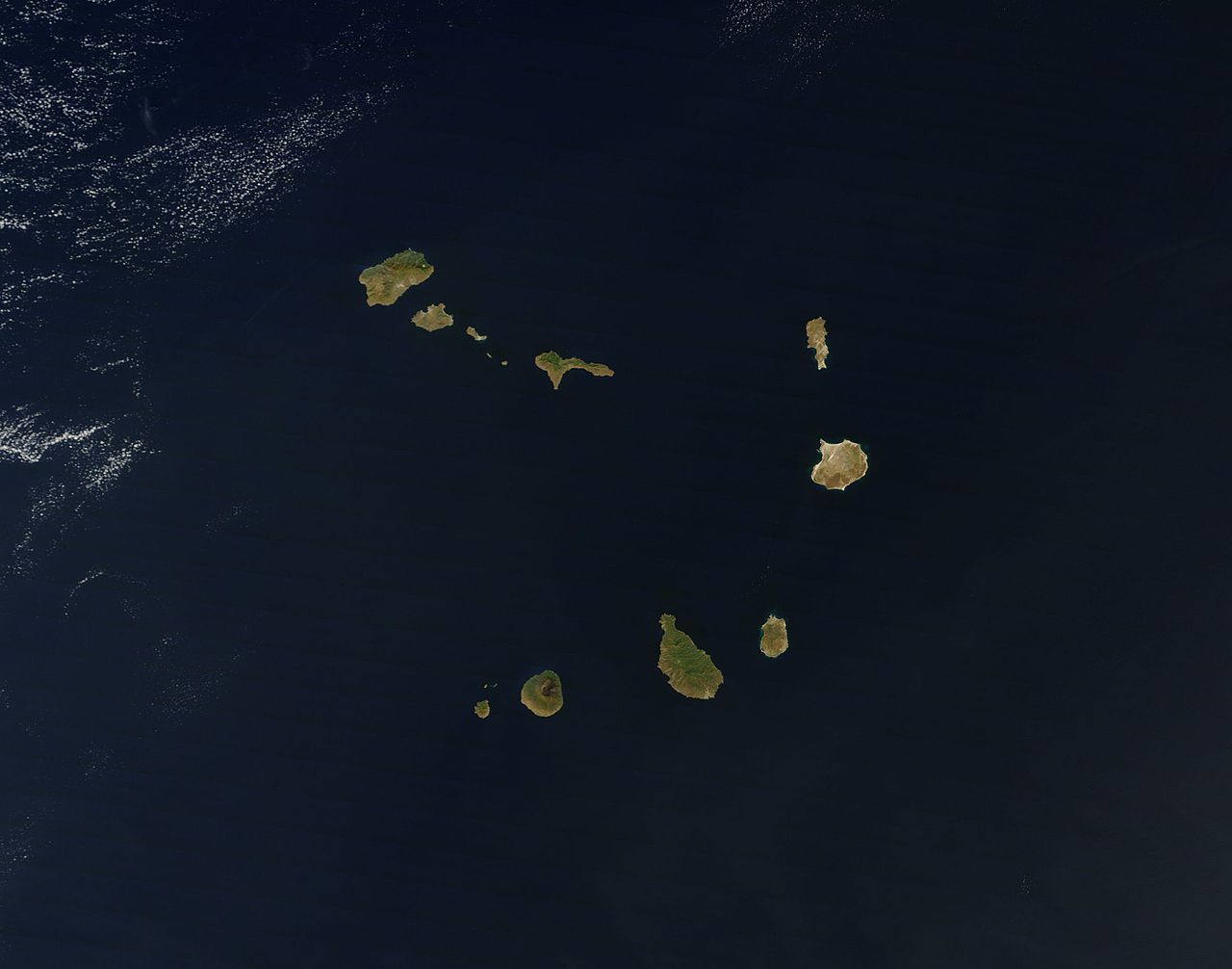
The islands are spatially divided into two groups:
The Barlavento Islands (windward islands): Santo Antão, São Vicente, Santa Luzia, São Nicolau, Sal, Boa Vista; and
The Sotavento Islands (leeward): Maio, Santiago, Fogo, Brava.
The largest island, both in size and population, is Santiago, which hosts the nation’s capital, Praia, the principal urban agglomeration in the archipelago.
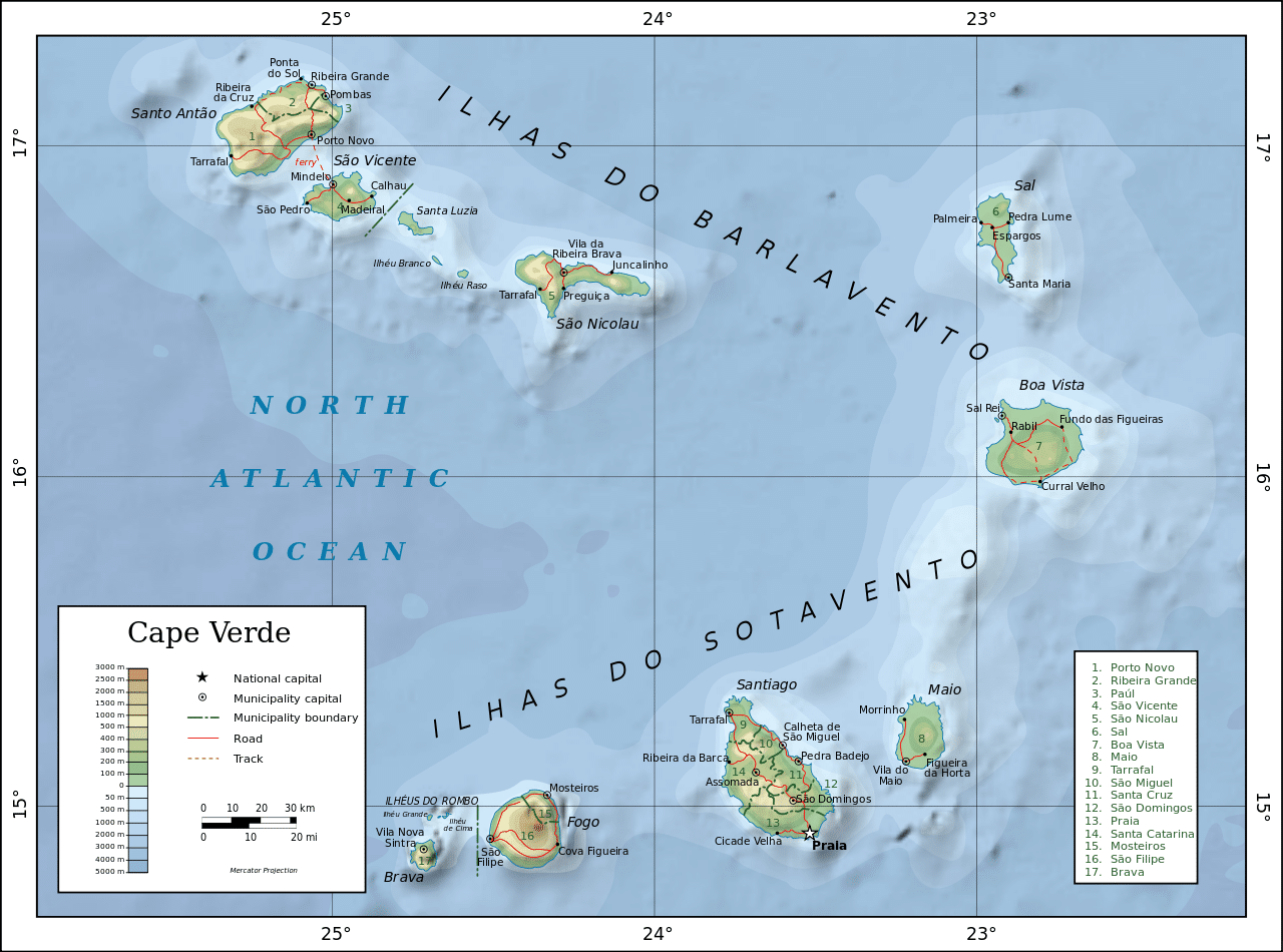
Three of the Cabo Verde islands, Sal, Boa Vista and Maio, are fairly flat, sandy, and dry; the others are generally rockier with more vegetation.
Economy:
Cabo Verde’s notable economic growth and improvement in living conditions despite a lack of natural resources has garnered international recognition, with other countries and international organizations often providing development aid. Since 2007, the UN has classified it as a developing nation rather than a least developed country.
Cabo Verde has few natural resources. Only five of the ten main islands (Santiago, Santo Antão, São Nicolau, Fogo, and Brava) normally support significant agricultural production, and over 90% of all food consumed in Cabo Verde is imported. Mineral resources include salt, pozzolana (a volcanic rock used in cement production), and limestone. Its small number of wineries making Portuguese-style wines have traditionally focused on the domestic market, but have recently met with some international acclaim. A number of wine tours of Cabo Verde’s various microclimates began to be offered in spring 2010.