Eswatini workers began anti-government protests against low salaries on 19 September 2018. They went on a three-day strike organised by the Trade Union Congress of Swaziland (TUCOSWA) that resulted in widespread disruption.
Geography:
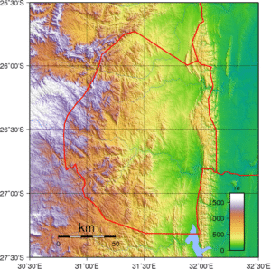
Eswatini lies across a fault which runs from the Drakensberg Mountains of Lesotho, north through the Eastern highlands of Zimbabwe, and forms the Great Rift Valley of Kenya.
A small, landlocked kingdom, Eswatini is bordered in the North, West and South by the Republic of South Africa and by Mozambique in the East. Eswatini has a land area of 17,364 km2. Eswatini has four separate geographical regions. These run from North to South and are determined by altitude. Eswatini has a wide variety of landscapes, from the mountains along the Mozambican border to savannas in the east and rain forest in the northwest. Several rivers flow through the country, such as the Great Usutu River.

Along the eastern border with Mozambique is the Lubombo, a mountain ridge, at an altitude of around 600 meters. The mountains are broken by the canyons of three rivers, the Ngwavuma, the Usutu and the Mbuluzi River. This is cattle ranching country. The western border of Eswatini, with an average altitude of 1200 meters, lies on the edge of an escarpment. Between the mountains rivers rush through deep gorges. Mbabane, the capital, is on the Highveld.
The Middleveld, lying at an average 700 metres above sea level is the most densely populated region of Eswatini with a lower rainfall than the mountains. Manzini, the principal commercial and industrial city, is situated in the Middleveld.
The Lowveld of Eswatini, at around 250 meters, is less populated than other areas and presents a typical African bush country of thorn trees and grasslands. Development of the region was inhibited, in early days, by the scourge of malaria.
Economy:
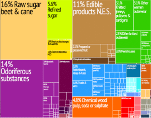
Eswatini’s economy is diverse, with agriculture, forestry and mining accounting for about 13% of GDP, manufacturing (textiles and sugar-related processing) representing 37% of GDP and services – with government services in the lead – constituting 50% of GDP. Title Deed Lands (TDLs), where the bulk of high value crops are grown (sugar, forestry, and citrus) are characterized by high levels of investment and irrigation, and high productivity.

About 75% of the population is employed in subsistence agriculture upon Swazi Nation Land (SNL). In contrast with the commercial farms, Swazi Nation Land suffers from low productivity and investment. This dual nature of the Swazi economy, with high productivity in textile manufacturing and in the industrialized agricultural TDLs on the one hand, and declining productivity subsistence agriculture (on SNL) on the other, may well explain the country’s overall low growth, high inequality and unemployment.
Economic growth in Eswatini has lagged behind that of its neighbors. Real GDP growth since 2001 has averaged 2.8%, nearly 2 percentage points lower than growth in other Southern African Customs Union (SACU) member countries. Low agricultural productivity in the SNLs, repeated droughts, the devastating effect of HIV/AIDS and an overly large and inefficient government sector are likely contributing factors. Eswatini’s public finances deteriorated in the late 1990s following sizable surpluses a decade earlier. A combination of declining revenues and increased spending led to significant budget deficits.
