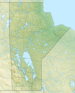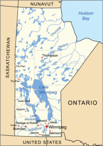
The province has a saltwater coastline bordering Hudson Bay and more than 110,000 lakes, covering approximately 15.6 percent or 39,225 square miles of its surface area. Manitoba’s major lakes are Lake Manitoba, Lake Winnipegosis, and Lake Winnipeg, the tenth-largest freshwater lake in the world. Some traditional Native lands and boreal forest on Lake Winnipeg’s east side are a proposed UNESCO World Heritage Site.
Manitoba is at the center of the Hudson Bay drainage basin, with a high volume of the water draining into Lake Winnipeg and then north down the Nelson River into Hudson Bay. This basin’s rivers reach far west to the mountains, far south into the United States, and east into Ontario. Major watercourses include the Red, Assiniboine, Nelson, Winnipeg, Hayes, Whiteshell and Churchill rivers. Most of Manitoba’s inhabited south has developed in the prehistoric bed of Glacial Lake Agassiz. This region, particularly the Red River Valley, is flat and fertile; receding glaciers left hilly and rocky areas throughout the province.

Baldy Mountain is the province’s highest point at 2,730 feet above sea level, and the Hudson Bay coast is the lowest at sea level. Riding Mountain, the Pembina Hills, Sandilands Provincial Forest, and the Canadian Shield are also upland regions. Much of the province’s sparsely inhabited north and east lie on the irregular granite Canadian Shield, including Whiteshell, Atikaki, and Nopiming Provincial Parks.
Extensive agriculture is found only in the province’s southern areas, although there is grain farming in the Carrot Valley Region (near The Pas). The most common agricultural activity is cattle husbandry (34.6%), followed by assorted grains (19.0%) and oilseed (7.9%).[15] Around 12 percent of Canada’s farmland is in Manitoba.
Economy:
Manitoba’s economy relies heavily on agriculture, tourism, energy, oil, mining, and forestry. Agriculture is vital and is found mostly in the southern half of the province, although grain farming occurs as far north as The Pas. Around 12 percent of Canadian farmland is in Manitoba. The most common type of farm found in rural areas is cattle farming (34.6%), followed by assorted grains (19.0%) and oilseed (7.9%).
Manitoba is the nation’s largest producer of sunflower seed and dry beans, and one of the leading sources of potatoes. Portage la Prairie is a major potato processing center, and is home to the McCain Foods and Simplot plants, which provide French fries for McDonald’s, Wendy’s, and other commercial restaurant chains. Can-Oat Milling, one of the largest oat mills in the world, also has a plant in the municipality.
Manitoba’s largest employers are government and government-funded institutions, including crown corporations and services like hospitals and universities. Major private-sector employers are The Great-West Life Assurance Company, Cargill Ltd., and James Richardson and Sons Ltd. Manitoba also has large manufacturing and tourism sectors. Churchill’s Arctic wildlife is a major tourist attraction; the town is a world capital for polar bear and beluga whale watchers. Manitoba is the only province with an Arctic deep-water seaport, at Churchill.
Transportation:
Greyhound Canada and Grey Goose Bus Lines offer domestic bus service from the Winnipeg Bus Terminal. The terminal was relocated from downtown Winnipeg to the airport in 2009, and is a Greyhound hub. Municipalities also operate localized transit bus systems.
