Thousands had left Puerto Rico, with close to 200,000 having arrived in Florida alone. Those who were then living on the mainland experienced difficulty in getting health care benefits. A The New York Times report on November 27 said it was understandable that Puerto Ricans wanted to leave the island. “Basic essentials are hard to find and electricity and other utilities are unreliable or entirely inaccessible. Much of the population has been unable to return to jobs or to school and access to health care has been severely limited.” The Center for Puerto Rican Studies at New York’s Hunter College estimated that some half million people, about 14% of the population, may permanently leave by 2019.
The total damage on the island was estimated at up to $95 billion. By the end of November, FEMA had received over a million applications for aid and had approved about a quarter of those. The US government had agreed in October to provide funding to rebuild and up to $4.9 billion in loans to help the island’s government. FEMA had $464 million earmarked to help local governments rebuild public buildings and infrastructure. Bills for other funding were being considered in Washington but little progress had been made on those.
Geography:
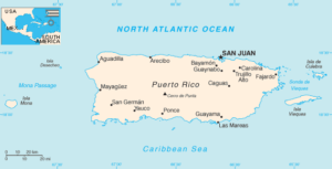
Puerto Rico consists of the main island of Puerto Rico and various smaller islands, including Vieques, Culebra, Mona, Desecheo, and Caja de Muertos. Of these five, only Culebra and Vieques are inhabited year-round. Mona, which has played a key role in maritime history, is uninhabited most of the year except for employees of the Puerto Rico Department of Natural Resources. There are many other even smaller islets, like Monito, which is near to Mona, Isla de Cabras and La Isleta de San Juan, both located on the San Juan Bay. The latter is the only inhabited islet with communities like Old San Juan and Puerta de Tierra, and connected to the main island by bridges.

The Commonwealth of Puerto Rico has an area of 5,320 square miles. Puerto Rico is larger than two U.S. states, Delaware and Rhode Island. Puerto Rico is the smallest of the Greater Antilles.
The island is mostly mountainous with large coastal areas in the north and south. The main mountain range is called “La Cordillera Central” (The Central Range). The highest elevation in Puerto Rico, Cerro de Punta, 4,390 feet, is located in this range.

Another important peak is El Yunque, one of the highest in the Sierra de Luquillo at the El Yunque National Forest, with an elevation of 3,494 feet.
Puerto Rico has 17 lakes, all man-made and more than 50 rivers, most originating in the Cordillera Central.
Economy:
The economy of Puerto Rico is classified as a high income economy by the World Bank and as the most competitive economy in Latin America by the World Economic Forum but Puerto Rico currently has a public debt of $72.204 billion, and a government deficit of $2.5 billion. Its economy is mainly driven by manufacturing (primarily pharmaceuticals, textiles, petrochemicals and electronics) followed by the service industry (primarily finance, insurance, real estate and tourism).
