
Vikings arrived at the end of the 8th century. They established Tynwald and introduced many land divisions that still exist. In 1266 King Magnus VI of Norway ceded the islands to Scotland in the Treaty of Perth. But Scotland’s rule over Mann did not become firmly established until 1275, when the Manx were defeated in the Battle of Ronaldsway, near Castletown.
In 1290 King Edward I of England sent Walter de Huntercombe to take possession of Mann. It remained in English hands until 1313, when Robert Bruce took it after besieging Castle Rushen for five weeks. In 1314, it was retaken for the English by John Bacach of Argyll. In 1317, it was retaken for the Scots by Thomas Randolph, 1st Earl of Moray and Lord of the Isle of Man. It was held by the Scots until 1333. For some years thereafter control passed back and forth between the kingdoms until the English took it for the final time in 1346. The English Crown delegated its rule of the island to a series of lords and magnates. Tynwald passed laws concerning the government of the island in all respects and had control over its finances, but was subject to the approval of the Lord of Mann.
In 1866, the Isle of Man obtained limited home rule, with partly democratic elections to the House of Keys, but the Legislative Council was appointed by the Crown. Since then, democratic government has been gradually extended.
The Isle of Man has designated more than 250 historic sites as registered buildings.
Geography:

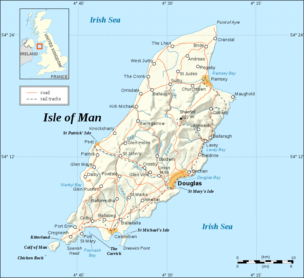
The Isle of Man is an island located in the middle of the northern Irish Sea, almost equidistant from England to the east, Northern Ireland to the west, and Scotland (closest) to the north; while Wales to the south is almost the distance of the Republic of Ireland to the southwest. It is 52 kilometers (32 mi) long and, at its widest point, 22 kilometers (14 mi) wide. It has an area of around 572 square kilometers (221 sq mi). Besides the island of Mann itself, the political unit of the Isle of Man includes some nearby small islands: the seasonally inhabited Calf of Man, Chicken Rock (on which stands an unmanned lighthouse), St Patrick’s Isle and St Michael’s Isle. The last two of these are connected to the main island by permanent roads/causeways.
Ranges of hills in the north and south are separated by a central valley. The northern plain, by contrast, is relatively flat, consisting mainly of deposits from glacial advances from western Scotland during colder times. There are more recently deposited shingle beaches at the northernmost point, the Point of Ayre. The island has one mountain higher than 600 meters (2,000 ft), Snaefell, with a height of 620 metres (2,034 ft). According to an old saying, from the summit one can see six kingdoms: those of Mann, Scotland, England, Ireland, Wales, and Heaven. Some versions add a seventh kingdom, that of the sea, or Neptune.
Economy:
The Isle of Man Department for Enterprise manages the diversified economy in 12 key sectors. The largest sectors by GNP are insurance and eGambling with 17% of GNP each, followed by ICT and banking with 9% each. The 2016 census lists 41,636 total employed. The largest sectors by employment are “medical and health”, “financial and business services”, construction, retail and public administration. Manufacturing, focused on aerospace and the food and drink industry, employs almost 2000 workers and contributes about 5% of gross domestic product (GDP). The sector provides laser optics, industrial diamonds, electronics, plastics and aerospace precision engineering. Tourism, agriculture, and fishing, once the mainstays of the economy, now make very little contributions to the island’s GDP.