Central Maine was formerly inhabited by people of the Androscoggin tribe of the Abenaki nation, also known as Arosaguntacook. Most finally withdrew to Canada.
The province within its current boundaries became part of Massachusetts Bay Colony in 1652. Maine was much fought over by the French, English, and allied natives during the 17th and early 18th centuries, who conducted raids against each other, taking captives for ransom or, in some cases, adoption by Native American tribes.
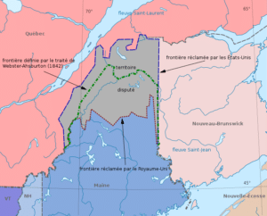
After the British defeated the French in Acadia in the 1740s, the territory from the Penobscot River east fell under the nominal authority of the Province of Nova Scotia. American and British forces contended for Maine’s territory during the American Revolution and the War of 1812, with the British occupying eastern Maine in both conflicts. The territory of Maine was confirmed as part of Massachusetts when the United States was formed following the Treaty of Paris ending the revolution, although the final border with British North America was not established until the Webster–Ashburton Treaty of 1842.

Maine was physically separate from the rest of Massachusetts. Long-standing disagreements over land speculation and settlements led to serious discontent and the first attempt at secession occurred in 1807; it failed. Secessionist sentiment in Maine was stoked during the War of 1812 when Massachusetts refused to defend Maine from British invaders. In 1819, Massachusetts agreed to permit secession, sanctioned by voters of the rapidly growing region the following year. Formal secession and formation of the state of Maine as the 23rd state occurred on March 15, 1820, as part of the Missouri Compromise.
Maine’s original state capital was Portland, Maine’s largest city, until it was moved to the more central Augusta in 1832.

The principal office of the Maine Supreme Judicial Court remains in Portland.
Geography:
To the south and east is the Atlantic Ocean and to the north and northeast is New Brunswick, a province of Canada. The Canadian province of Quebec is to the northwest. Maine is both the northernmost state in New England and the largest, accounting for almost half the region’s entire land area. Maine is the only state to border exactly one other state, New Hampshire to the west.
Maine is the easternmost state in the United States in both its extreme points and its geographic center.
Mount Katahdin is both the northern terminus of the Appalachian Trail, which extends southerly to Springer Mountain, Georgia, and the southern terminus of the new International Appalachian Trail which, when complete, will run to Belle Isle, Newfoundland and Labrador.

Maine has several unique geographical features. Machias Seal Island and North Rock, off its easternmost point, are claimed by both the U.S. and Canada and are within one of four areas between the two countries whose sovereignty is still in dispute, but it is the only one of the disputed areas containing land. Also in this easternmost area in the Bay of Fundy is the Old Sow, the largest tidal whirlpool in the Western Hemisphere.
