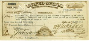
After the United States bought what is now known as the United States Virgin Islands from the Danish, the islands officially became an unincorporated U.S. territory in 1927. Most residents were granted U.S. citizenship in 1936. The islands remained under the direct control of the U.S. government until 1968, when residents were first allowed to elect their own Governor. In 1972, residents elected their first non-voting delegate to congress.
The 1930s represented a watershed as the economy reversed itself because of two external stimuli: the repeal of prohibition in the U.S., which greatly increased the demand for plantation workers, and the wartime decision to construct a submarine base on the islands of St. Thomas. Because of habitual out-migration to the U.S. and the historical absence of a peasant agricultural tradition, the indigenous labor supply was inadequate. This vacuum created the demand for West Indian Labor from the Eastern Caribbean for the first of several immigrant waves.
The Organic Act of the Virgin Islands of the United States of 1936 established a government for the U.S. Virgin Islands, replacing previous temporary provisions.
The Virgin Islands Government set a new policy of export diversification via tourism and light industry. People continued to immigrate in substantial numbers — some legally and others illegally. They benefited from a series of loose interpretations and favorable revisions of immigration law which reduced occupational restrictions and generally lax enforcement.
In 1954, the Revised Organic Act of the Virgin Islands repealed and replaced the previous Organic Act of the Virgin Islands.
Hurricane Hugo struck the U.S. Virgin Islands in 1989, causing catastrophic physical and economic damage, particularly on the island of St. Croix. The territory was again struck by Hurricane Marilyn in 1995, killing eight people and causing more than $2 billion in damage. The islands were again struck by Hurricanes Bertha, Georges, Lenny, and Omar in 1996, 1998, 1999, and 2008, respectively, but damage was not as severe in those storms. In 2017, Hurricane Irma caused catastrophic damage to St. John and St. Thomas; just days later, Hurricane Maria‘s eyewall crossed over St. Croix.
Until February 2012, the Hovensa plant located on St. Croix was one of the world’s largest petroleum refineries and contributed about 20% of the territory’s GDP. The facility stopped exporting petroleum products in 2014. In the final year of full refinery operations, the value of exported petroleum products was $12.7 billion. After being shut down, it has operated as no more than an oil storage facility; the closure had provoked a local economic crisis.
Geography:
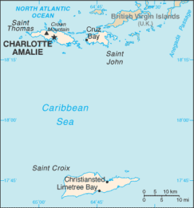
The United States Virgin Islands are a group of several dozen islands and cays located in the Caribbean, about 1,100 miles southeast of Florida, 600 miles north of Venezuela, 40 miles east of Puerto Rico, and immediately west and south of the British Virgin Islands.

The U.S. Virgin Islands lie near the boundary of the North American Plate and the Caribbean Plate, roughly 100 miles south of the Puerto Rico Trench and near the Anegada Passage, a key shipping lane. Together with the British Virgin Islands, Vieques, and Culebra, they make up the Virgin Islands archipelago.
