The hilly, volcanic islands of Saint Thomas (31 square miles) and Saint John (20 square miles) border the North Atlantic Ocean to the north and the Caribbean Sea to the south. The larger island of Saint Croix (84 square miles) lies 40 miles to the south across the Virgin Islands Trough and is entirely in the Caribbean Sea.
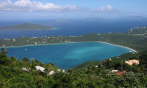
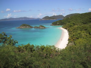
Charlotte Amalie, Saint Thomas is one of the best natural, deep-water harbors in the Caribbean. The Islands have many well-known beaches, including Magens Bay (Saint Thomas)

and Trunk Bay (Saint John), and coral reefs, including the Virgin Islands Coral Reef National Monument and the Buck Island Reef National Monument. More than half of Saint John and nearly all of Hassel Island are owned by the U.S. National Park Service.

The U.S. Virgin Islands lie on the boundary of the North American plate and the Caribbean Plate. Natural hazards include earthquakes and hurricanes.
Crown Mountain, on Saint Thomas, is the highest point in the U.S. Virgin Islands. Sea level is the lowest.
Economy:
In May 2016 the islands’ Bureau of Economic Research indicated that there were 37,613 non-agricultural wage and salary jobs in the islands. This report states that the “leisure and hospitality sector” employed an average of 7,333 people. The retail trade sector, which also serves many tourists, averaged another 5,913 jobs. Other categories which also include some tourism jobs include Arts and Entertainment (792 jobs), Accommodation and Food (6,541 jobs), Accommodation (3,755 jobs), Food Services and Drink (2,766 jobs). A large percentage of the 37,613 non-farm workers are employed in dealing with tourists. Serving the local population is also part of the role of these sectors.
Tourism:
Tourism, trade, and other service-oriented industries are the primary economic activities, accounting for nearly 60% of the GDP. Approximately 2.5 million tourists per year visit, most arriving on cruise ships. Such visitors do not spend large amounts of money ($146.70 each on average) but as a group, they contributed $339.8 million to the economy in 2012.
Manufacturing:
The manufacturing sector consists of mainly rum distilling. The agricultural sector is small, with most food being imported. International business and financial services are a small but growing component of the economy. Most energy is also generated from imported oil, leading to electricity costs four to five times higher than the U.S. mainland. The Virgin Islands Water and Power Authority also uses imported energy to operate its desalination facilities to provide fresh water.
Transportation:
Roadways:
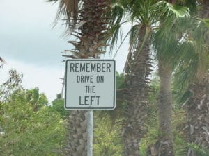
The U.S. Virgin Islands is the only US jurisdiction that drives on the left.

This was inherited from what was then-current practice on the islands at the time of the 1917 transfer of the territory to the United States from Denmark. However, because most cars in the territory are imported from the mainland United States, the cars in the territory are left-hand drive. The USVI have 1,230 miles of roadways, about 750 miles of public roads and 490 miles of private roads. Most public roads are two-lane and are paved with asphalt or concrete. There are few shoulders. Guts (culverts) and retaining walls help prevent flooding and landslides. Private roads are often unpaved or semi-paved.
Public Transportation:
Virgin Islands Transit (VITRAN) public buses run between the main towns and areas of local interest (not tourist destinations). Bus fare is $1 or less. Privately owned “dollar ride” or “dollar run” taxi buses stop at or near many bus stops. They follow a predefined route, but do not follow a regular schedule. It is often possible to get off anywhere along their route. These buses charge a flat rate for the trip, either $1 or $2.
