
A detailed and extensive history of Alberta may be found elsewhere.
Geography:
Alberta, with an area of 255,500 square miles, is the fourth-largest province after Quebec, Ontario and British Columbia.
Alberta’s southern border is the 49th parallel north, which separates it from the U.S. state of Montana; while the 60th parallel north divides it from the Northwest Territories. The 110th meridian west separates it from the province of Saskatchewan; while on the west its boundary with British Columbia follows the 120th meridian west south from the Northwest Territories at 60°N until it reaches the Continental Divide at the Rocky Mountains, and from that point follows the line of peaks marking the Continental Divide in a generally southeasterly direction until it reaches the Montana border at 49°N.
The province extends 760 miles north to south and 410 miles east to west at its maximum width. Its highest point is 12,293 feet at the summit of Mount Columbia in the Rocky Mountains along the southwest border while its lowest point is 499 feet on the Slave River in Wood Buffalo National Park in the northeast.
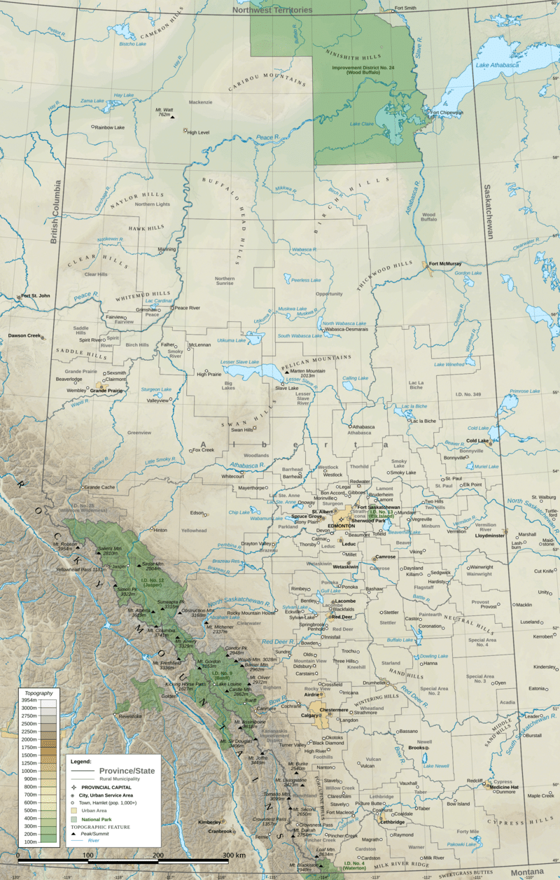
With the exception of the semi-arid steppe of the south-eastern section, the province has adequate water resources. There are numerous rivers and lakes used for swimming, fishing and a range of water sports. There are three large lakes, Lake Claire 554 square miles in Wood Buffalo National Park, Lesser Slave Lake 451 square miles, and Lake Athabasca 3,049 square miles which lies in both Alberta and Saskatchewan. The longest river in the province is the Athabasca River which travels 956 miles from the Columbia Icefield in the Rocky Mountains to Lake Athabasca.
Alberta’s capital city, Edmonton, is located at about the geographic center of the province. It is the most northerly major city in Canada, and serves as a gateway and hub for resource development in northern Canada. The region, with its proximity to Canada’s largest oil fields, has most of western Canada’s oil refinery capacity. Calgary is about 170 miles south of Edmonton and 150 miles north of Montana, surrounded by extensive ranching country. Almost 75% of the province’s population lives in the Calgary–Edmonton Corridor. The land grant policy to the railroads served as a means to populate the province in its early years.
Most of the northern half of the province is boreal forest, while the Rocky Mountains along the southwestern boundary are largely forested. The southern quarter of the province is prairie, ranging from shortgrass prairie in the southeastern corner to mixed grass prairie in an arc to the west and north of it. The central aspen parkland region extending in a broad arc between the prairies and the forests, from Calgary, north to Edmonton, and then east to Lloydminster, contains the most fertile soil in the province and most of the population. Much of the unforested part of Alberta is given over either to grain or to dairy farming, with mixed farming more common in the north and center, while ranching and irrigated agriculture predominate in the south.