Starting back in 1937, the Fullard-Leo family began attempts to lease Palmyra to the U.S. Navy. During negotiations, the government filed a quiet title action against the Fullard-Leos and Henry Ernest Cooper’s six surviving children, claiming that there had never been any private property at Palmyra under the Kingdom of Hawaii or later. The case went all the way up to the Supreme Court. The previously mentioned Insular Areas report goes on to state, “While the suit was pending during World War II, the Navy occupied Palmyra and built a runway and several buildings.” The Fullard-Leos and Coopers finally won their case in United States v. Fullard-Leo et al. 1947, which quieted good land title against the federal government in favor of private landowners. The opinion acknowledged certain of Henry Maui’s and Joseph Clarke’s interests, but their heirs and their successor Mrs. Bella Jones were not made parties to the case. As of 2007, descendants of Henry Cooper still owned the two small islets not sold in 1922.
In July 1938, then Secretary of the Interior Harold L. Ickes wrote a letter to President Roosevelt, imploring him not to turn Palmyra over to the US Navy for use as a military base. Quoting his letter, he writes:
“…the Navy Department has plans for the acquisition and development of the island as an air base. Our representatives have studied conditions at Palmyra and other islands in the south Pacific, and they report that use of this small land area as an air base for Navy Department purposes would undoubtedly destroy much, if not all, that makes the island one of our most scientifically and scenically unique possessions.”
The letter was unsuccessful, and plans for the base proceeded.
On February 14, 1941, President Franklin Roosevelt issued Executive Order 8682 to create naval defenses areas in the central Pacific territories. The proclamation established “Palmyra Island Naval Defensive Sea Area” which encompassed the territorial waters between the extreme high-water marks and the three-mile marine boundaries surrounding the atoll. “Palmyra Island Naval Airspace Reservation” was also established to restrict access to the airspace over the naval defense sea area. Only U.S. government ships and aircraft were permitted to enter the naval defense areas at Palmyra Atoll unless authorized by the Secretary of the Navy.

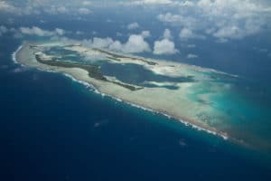
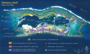
The Navy took over the atoll for use as the Palmyra Island Naval Air Station on August 15, 1941. From November 1939 through 1947, the atoll had resident Federal Government representatives, the island commanders. The atoll was shelled by a Japanese submarine in 1941, with no significant damage or injuries. The government made extensive alterations to the land forms. It blasted and dredged a ship channel from the open sea into the West Lagoon, which had been completely enclosed by islands and reef and was non-navigable until the channel reached the lagoon on May 15, 1941. It joined islands with causeway roads, built new islands and extended existing islands with dredged coral spoil, including the main runway on Cooper Island, an emergency landing strip called Sand Island joined by a causeway to Home Island, and two artificial runway islands that were not completed. These alterations blocked the water flow through the atoll and are believed to have severely harmed the natural ecology of the lagoons.
